There is some positive news in the fight against several notable wildfires burning in B.C., even as officials caution there are difficult days ahead.
The province is warning that conditions continue to be volatile and the number of wildfires continues to grow, with more than 430 blazes recorded as of Wednesday morning.
But rain in the north has lessened the wildfire risk in that region, and in the south, crews have been able to establish defences against wildfires that are threatening communities including Ashcroft, Wells and the historic town of Barkerville.
Here is an update on some of the notable wildfires in this province on Wednesday.
Shetland Creek wildfire shows no new growth
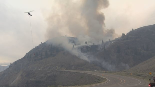
On Tuesday, the B.C. Wildfire Service posted an update on the Shetland Creek wildfire, which has been holding in size at just under 200 square kilometres, with no new growth in the past day.
The fire has forced the evacuation of more than 120 people from the Venables Valley and has destroyed 20 buildings, including six homes, according to Colton Davies with the Thompson-Nicola Regional District.
It has also placed the community of Ashcroft and a portion of Cache Creek on evacuation alert as hot and dry conditions coupled with gusty winds have driven the blaze northward.
WATCH | Fighting the Shetland Creek wildfire:
Jeff Walsh, an incident commander with the B.C. Wildfire Service, says in the video that crews are using heavy equipment on the mountain slopes above Spences Bridge to prevent fire from burning downslope toward the southern Interior community.
“Currently our main focus is establishing containment where it’s safe and operable to do so,” Walsh says.
In a Facebook post Tuesday night, Ashcroft Mayor Barbara Roden said she had been told that a drop in temperature had led to higher humidity levels, helping stop the growth of the fire. She also said the fire had started spreading toward areas that had previously been burned, where there is less fuel.

As a result, Highway 1 between Ashcroft and Cache Creek, which had been closed due to wildfire risk, reopened Tuesday though it could be closed once more should conditions change.
Roden said a forecast of lower temperatures and rain later in the week were also buoying optimism, though she cautioned there was still no word on when evacuation orders and alerts might be lifted.
‘Humidity bubble’ established around Barkerville Historic Park
There has been similar good news for the Antler Creek wildfire, which has forced the evacuation of about 120 people from the District of Wells, as well as the neighbouring gold rush-era Barkerville Historic Park and Bowron Lake Provincial Park.
On Tuesday afternoon, the wildfire service said the fire had expanded beyond 140 square kilometres and was now just three kilometres from Wells and Barkerville.
There have been some structures lost, according to Wells Mayor Ed Coleman. He told CBC News Wednesday that this includes two homes.

The wildfire service also said it had managed to establish control lines and a “humidity bubble” in Barkerville and the surrounding area. They have hooked up multiple sprinklers to the existing water system in an attempt to minimize the fire risk to the old, wooden buildings, some of which are more than 100 years old.
The service said it was expecting the fire to increase in size in the coming days, as it could merge with other, smaller blazes in the area.
Cluster of fires sparked near Wells Gray Park and Clearwater
In Clearwater, about 100 kilometres north of Kamloops, there are roughly 20 wildfires burning, dropping ash and keeping crews busy, said Mayor Merlin Blackwell.
Another 60 kilometres north, Wells Gray Provincial Park has been partially closed due to a wildfire near Murtle Lake. The park is a popular destination for campers, canoers, kayakers and hikers.
Daybreak Kamloops9:20Multiple fires affecting North Thompson, Well Gray Park
Clearwater mayor Merlin Blackwell is watching more than 20 fires burning in his region including several that have caused major closures in Wells Gray Provincial Park.
While Blackwell said there was concern about the impacts on the fire on communities, he emphasized that many areas were still open to tourists.
“You can still come here; you just need to have your sense about you,” he said.
About 100 kilometres northwest of Clearwater, the community of Lac La Hache has issued a water quality notice due to wildfire fighting efforts in the area depleting a local reservoir.
New evacuations due to Sooke Potholes wildfire
A Sooke-area wildfire, known as the Old Man Lake wildfire, continues to burn out of control on Vancouver Island.
The fire was discovered on Monday afternoon in Sooke Potholes Park on Vancouver Island, about 27 kilometres west of Victoria.
The regional park, a popular destination for hikers, cyclists and campers, was closed and evacuated, as was an adjacent provincial park, Sea to Sea Regional Park, and a portion of the Galloping Goose trail.
According to the B.C. Wildfire Service, the fire has since grown to 1.69 square kilometres and is still listed as out of control, though it does not pose a current threat to any homes.

In an interview Thursday afternoon, Sooke Mayor Maya Tait said that, in positive news, the wildfire was largely growing away from the community.
In a bulletin, the Capital Regional District said that while water quality in Greater Victoria is not currently impacted, that could change if ash begins drifting onto the Sooke Lake Resevoir.
Environment Canada forecasts temperatures may drop a couple degrees in the area, but dry conditions will persist into the weekend.
All Points West7:10Sooke Mayor Maya Tait gives an update on the Old Man Lake Fire
The Old Man Lake fire burning near Sooke isn’t threatening any homes or structures, but has caused smoky conditions in Greater Victoria. Sooke Mayor Maya Tait joined us with an update on the fire and the impact on the community.
Australian team takes over Kootenay wildfires
In the Kootenay region, an incident management team from Australia is taking over command of the Slocan Lake complex of wildfires, which includes the Aylwin Creek, Komonkoko Creek, Nemo Creek, Ponderosa FSH and Mulvey Creek burns.

Combined, the fires have prompted multiple evacuation orders and alerts that are being managed by the Regional District of the Central Kootenay.
Heat warnings for the region have been rescinded, although daytime highs are still expected to be up to 36 C for the remainder of the week, with lows from the mid-teens to low 20s.
Daybreak South7:58A man from the Slocan Valley guided wildfire crews to a fire burning near his home
Ron LeBlanc has been out of his home since Sunday night, when an evacuation order was issued. He shares what the last few days have been like after being evacuated from his home on Sunday due to the Mulvey Creek fire.
Daybreak South6:36RDEK provides an update on fires with cooler temperatures in the forecast.
Loree Duczek is the Information Officer for the regional emergency operations centre, She shares an update on several fires that are burning within the RDEK. Areas E and F are currently under a local state of emergency due to those fires.