B.C. coast braces for high winds, power outages, travel disruption as ‘bomb cyclone’ forms in Pacific
Forecasters are warning of hurricane-level wind gusts as a “bomb cyclone” forms off the coast of Vancouver Island.
Wind warnings issued Monday evening cover the entirety of B.C.’s coast, with Environment Canada saying easterly wind speeds of 90 km/h, gusting up to 120 km/h, will develop starting Tuesday afternoon.
A cyclone is the term used when masses of warm and cool air collide to create spiralling winds, with forecasters saying the “bomb” portion of the name refers to a rapid pressure drop of over 24 millibars (the unit used to measure air pressure) in 24 hours.
The bomb cyclone currently forming 400 kilometres west of Tofino, B.C., could see a pressure drop of 60 millibars over a 24-hour stretch in the centre of the storm — which forecasters say is highly unusual for B.C.
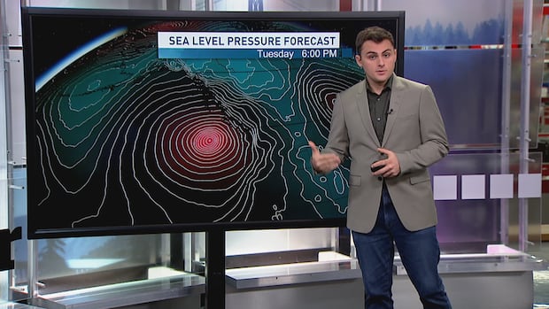
CBC science communicator Darius Mahdavi said current modelling shows the storm’s central pressure could be comparable to that of a Category 3 or 4 hurricane.
He said parts of the North Coast will likely see the strongest winds, with gusts up to 150 km/h.
Brian Proctor, an Environment Canada meteorologist, said the strong low-pressure system off the coast will also cause strong easterly outflow winds to rip through B.C.’s coastal valleys.
“We’re likely to see power outages. I wouldn’t be surprised to see B.C. Ferries having some shutdowns as well [Tuesday] through the afternoon, evening hours,” Proctor told CBC News on Monday.
B.C. Ferries has issued a travel advisory in anticipation of the storm, lasting through until Wednesday. Customers are being asked to check the ferry service’s website ahead of travel.
As of noon PT on Tuesday, several evening sailings between the Lower Mainland and Vancouver Island have been cancelled. Sailings between Metro Vancouver and the Sunshine Coast and one between Sechelt and Powell River have also been cancelled.
B.C. Ferries says Northern Gulf Island sailings are at risk of cancellations.
Armel Castellan, another meteorologist with the weather office, said the strong outflow winds from the Interior that will arrive on Tuesday afternoon are something officials hadn’t seen yet so far this season.
“When we talk about wind strength, we also need to talk about wind direction. And we consider that the first time we see a strong wind in a new direction as a time to be vigilant,” he said.
“Because the forests — or certainly the trees that line our power cables, transmission lines — are going to be tested in a new way.”

Proctor says that the bomb cyclone will also bring some rain and snow at higher elevations to much of coastal B.C. — though the amounts wouldn’t be as much as an atmospheric river system that brought flash floods to the South Coast in October.
“If this flow is coming in 200 or 300 kilometres further to the east, we would be seeing tremendous impacts upon the inner South Coast and all of Vancouver Island,” Proctor said.
Mahdavi said higher elevations in some areas could get nearly a metre of snow by Wednesday night.

A hurricane is described as a cyclone with sustained wind speeds of at least 119 km/h, according to the Canadian Hurricane Centre.
Tuesday’s storm is the second major windstorm to hit B.C.’s South Coast in a week, with one that hit on Nov. 12 causing tens of thousands of properties to lose power.
CBC science specialist Darius Mahdavi breaks down the incoming windstorm that is forming off the west coast of Vancouver Island, with its effects set to be most severe on Tuesday night.
Concern for ships
Cliff Mass, a professor of atmospheric and climate sciences at the University of Washington in Seattle, categorized the wind speeds from the incoming storm as “hurricane force” and said the storm would affect the entire West Coast of North America down to California.
“No ship should go through the Strait of Juan de Fuca tomorrow [Tuesday],” the scientist said on Monday. “[Tuesday] afternoon, evening will not be a good time.”

Sean Baxter, the harbour master for the Vancouver Fraser Port Authority, said the port was already in touch with shipping companies and stakeholders over the incoming storm.
He said incoming ships would be offered anchorages off the coast to mitigate the impact of the storm.
“Given that it is peak export season now, anchorages are being well utilized, as critical port capacity, to allow vessels to have a safe place to wait out the storm,” he said.
Communities preparing
Communities on Vancouver Island are preparing for downed lines and power outages.
“We’ve got extra crews on standby,” Metchosin Fire Chief Stephanie Dunlop told CBC’s On The Island host Gregor Craigie on Tuesday morning.
“We’re also co-ordinating with our public work crews on how we can … block roads and and just keep everybody safe.”
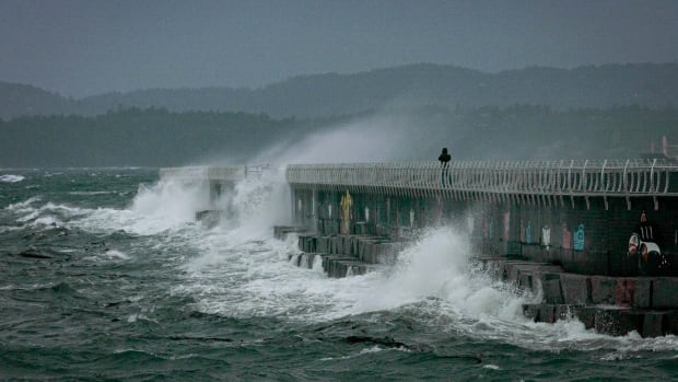
In Victoria, preparations look much the same, according to David McAra, the city’s acting assistant director of engineering and public works. He said crews will be preparing backup generators and preparing for road closures where needed — in particular, McAra said, in spots where waves breach the seawall and bring debris up onto the road.
“I think this is the third major sort of storm event in November,” he said. “So we’ve had a little bit of practice.”
B.C.’s Ministry of Transportation and Transit is reminding drivers that weather conditions can change suddenly and they need to be prepared when heading out on the road.
Most highways in B.C. require vehicles to have winter tires or chains from Oct. 1 until April 30. Drivers can check DriveBC for the latest road conditions along their planned route.


