A man has been rescued from a landslide along the Chilcotin River, about 100 kilometres southwest of Williams Lake in the B.C. Interior.
Evacuations have also been ordered for the area due to the “immediate risk of flooding,” affecting a dozen homes, according to officials.
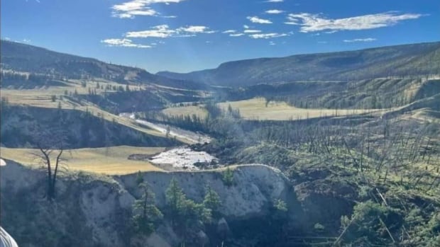
The slide happened overnight, with the rescue taking place Wednesday morning in an area referred to by the Tŝilhqot’in National Government as Nagwentled, also known as Farwell Canyon, which is a destination for hikers, campers and mountain bikers.
The slide was discovered by Ken Ilincki, who operates a nearby ranch with his wife, Deb Ilincki. She told CBC News that when he went out to the site, there was a man calling out from the opposite side of the river, saying he was trapped.
“I guess he had been floating in the river and camping there,” she said. “And just by sheer luck, he’s — well, he was injured, but how he wasn’t buried is surprising. He was just in the right spot, I guess.”
Ilincki, who has since been ordered to leave her home due to flood risk, says her husband called search and rescue crews, who were able to transport the man away with what appeared to be a broken leg.
Debra Bortolussi, a spokesperson for Central Cariboo Search and Rescue, told CBC’s Radio West that the man was rafting down the river with his dog Tuesday and had set up camp for the night when he heard the landslide starting. He then sustained “stable injuries” while running away.
The man is now receiving treatment at the Cariboo Memorial Hospital in Williams Lake, she said.
But the dog — an Australian Shepherd Border Collie mix named Seko — is yet to be found. Seko, who is black and gray, was wearing a collar and a tag.
“When he got up and started to run, he also told his dog to run,” Bortolussi said. “We don’t know where the dog is, but we’re very hopeful that we’ll be able to find the pup.”
Evacuations ordered
According to Bortolussi, the area is remote, and it is most often accessed only by rafters going down the river. It is a popular rafting route, so she said Central Cariboo Search and Rescue is “on standby waiting to respond” to any other rafters who might be injured or stranded by the low water levels.
According to Brian Menounos, professor of earth sciences at the University of Northern British Columbia, the area is susceptible to landslides and there have been some recorded in the past. This landslide, he said, “appears to be a larger event.”
Bortolussi described the landslide as “very significant.” She is encouraging everyone to stay away until officials can fully assess the landslide’s risks and damage.
“There will be massive, massive repercussions from something of this size,” she said.
On Wednesday, the river appeared to be completely blocked, according to Gerald Pinchbeck from the Cariboo Regional District’s emergency operations centre. This comes with its own set of risks, including flooding upstream in the near future and flash flooding downstream as the landslide is cleared.
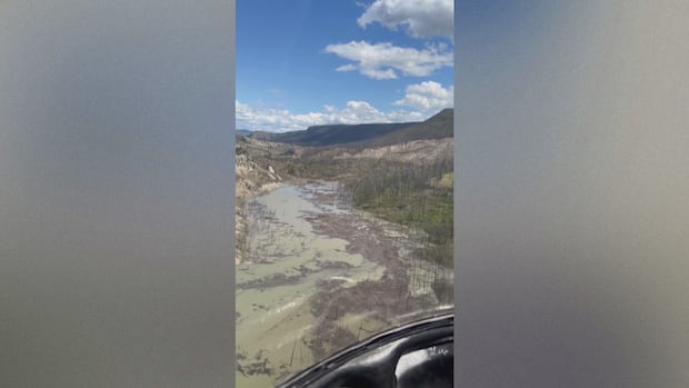
Footage shared by Williams Lake First Nation chief Willie Sellars shows the aftermath of a landslide in the B.C. Interior that has blocked a major river tributary, prompting evacuations and flood warnings.
It would also affect fisheries operations for First Nations in the region, he said. The Tŝilhqot’in says the river is one of the most important salmon-bearing tributaries of the Fraser River.
“It’s really hard not to get emotional about it,” said Chief Willie Sellars of the Williams Lake First Nation. “We’ve already been hit with historical lows [with] regards to sockeye and chinook salmon for the territory — something that we hold very close to our to our hearts, in our way of life as Indigenous peoples from the interior of British Columbia.”
The Tŝilhqot’in National Government says it has activated its emergency operations centre, as well, and is urging people to stay away from the area due to unpredictable water flow.
The Cariboo Regional District has ordered evacuations for 60 parcels of land along the river, covering about 106 square kilometres of land, due to the risk of imminent flooding. Pinchbeck told CBC News that the order affects 12 homes and around 13 residents.

An interactive map shows the area stretches from near the southern tip of Beaumont Road to where the Chilcotin and Fraser rivers meet, about 30 kilometres to the west.
RCMP are helping enforce the order, the district says in a statement.
On Wednesday afternoon, the province’s River Forecast Centre issued a flood warning for the river upstream of the landslide near the Farwell Canyon.
Officials have also issued a flood watch for the Chilcotin River downstream of the landslide near the Farwell Canyon, as well as the Fraser River, for areas downstream of where it meets the Chilcotin.
In addition, there is an high streamflow advisory for the Fraser River downstream of Hope.
The Lytton Ferry will also be closed at 10 p.m. PT Wednesday as a result of “potential dangerous debris flow” from the landslide.