The Cook’s Ferry Indian Band, north of Spences Bridge in the B.C. Interior, has issued an updated evacuation order for several reserves due to a pair of out-of-control fires.
The band first issued an order Tuesday, which applied to Reserve 6 due to imminent danger from the K70910 (Shetland Creek) and K70913 (Teit Creek) fires
The new order, which came into effect at 8 p.m. PT Wednesday, now covers Reserves 5, 6, 8A, 19 Firstly and 22.
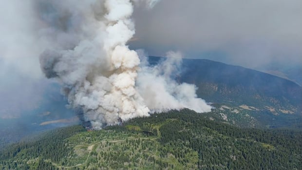
The B.C. Wildfire Service says the Teit Creek fire is about 250 hectares in size, with the Shetland Creek fire being around 285 hectares in size. Both fires are believed to have been sparked by lightning.
An hour after the First Nation’s order, an evacuation order from the Thompson-Nicola Regional District (TNRD) in response to the Shetland Creek fire also came into effect.
This order covers around 76 properties in Electoral Area I (Blue Sky Country), which could affect approximately 100 people according to TNRD information officer Colton Davies.
The TNRD Emergency Operations Centre has issued an Evacuation Order for Venables Valley, located in Electoral Area “I” (Blue Sky Country) due to the Shetland Creek wildfire.<br><br>Evacuees can report to the <a href=”https://twitter.com/hashtag/CacheCreek?src=hash&ref_src=twsrc%5Etfw”>#CacheCreek</a> Community Hall.<br><br>More information: <a href=”https://t.co/uvXGlenNQQ”>https://t.co/uvXGlenNQQ</a> <a href=”https://t.co/VHHOKh4McG”>pic.twitter.com/VHHOKh4McG</a>
—@TNRD
Davies also told CBC News that there were “very significant winds” in the area earlier Wednesday evening, but those seemed to have calmed late Wednesday night.
“That’s obviously an ongoing issue with the hot and dry conditions and the heat warning that continue in this area and much of our regional district boundary,” the information officer said. “We’re continuing to be on high alert.”
Evacuees from both groups are advised to report to the Cache Creek Community Hall.
The band has also issued a new evacuation alert for Reserves 5A, 8, 9, 11A, 18 and 20, with the TNRD also issuing an evacuation alert for 25 properties along Highway 1 north of Spences Bridge.
Dry forest conditions
Over a dozen new fires have sparked across the province over the last 24 hours, and the B.C. Wildfire Service says dry forests in much of the province are “very receptive to ignition.”
The wildfire service’s online dashboard, as of 5 p.m. PT Wednesday, reports 161 active wildfires in B.C. Within the last 24 hours, 16 more fires have started and 41 were declared out. In the last seven days, 136 were declared out.
There are no wildfires of note, meaning fires that are considered highly visible or a potential risk to public safety.
Officials have long been worried about a “challenging” wildfire season this year, as a months-long drought persists provincewide.
Heat warnings are in effect across B.C., which could fuel the growth of new and existing fires, officials say.
“With a heat wave ongoing for over two weeks, forest fuels are dry,” a situation report from the wildfire service reads.
“Hot and dry conditions are set to continue into the latter half of the week into the weekend, with widespread thunderstorms and strong winds forecast for Friday and Sunday.”
Highway 97 reopened
One new fire led to the closure of Highway 97 between Peachland and Summerland, in B.C.’s Okanagan.
For much of the day, the road was closed in both directions, but by mid-afternoon, it was open to single-lane alternating traffic.
Photos and video posted to social media show flames and smoke at the road’s edge, apparently burning up a hillside.
The B.C. Wildfire Service described the fire, now being held, as six hectares in size in an online report. It was assessed as rank one or two, “meaning a smouldering ground fire, with some visible open flame.”
It is suspected to be human-caused. In B.C., human-caused wildfires are defined as any blaze that isn’t caused by lightning.
Wildfire service crews and firefighters from Peachland and Summerland fought the flames, supported by aircraft.
Mt. Morro Fire
Crews are cautiously watching a new fire in Top of the World Provincial Park in the Kootenay Ranges of the Rocky Mountains.
The Mt. Morro fire is currently estimated to cover 40 hectares, and a B.C. Wildfire Service spokesperson described the blaze as showing “strong” behaviour.
“The size can change pretty regularly,” fire information officer Kim Wright said.
Wright said the fire is located in “extremely steep and inaccessible terrain.”
She said crews are using a “modified response,” meaning a combination of techniques like direct and indirect attacks, monitoring and steering it within a certain perimeter.
B.C. Parks says Top of the World Park is closed because of the fire.
Falls Creek fire
Drivers may also be able to see smoke from an out-of-control wildfire discovered Tuesday afternoon along Highway 1 north of Hope, officials say. Crews are attacking the blaze.
The fire at Falls Creek, 77 km north of Hope, B.C., and 144 km north of Vancouver, was described Wednesday by the wildfire service as just over two hectares in size.

Several fire crews and two helicopters, along with staff from CN Rail, are on scene at that fire.
The fire is believed to be human-caused. There are no evacuation orders or alerts because of the fire nor are there any access restrictions.
“Smoke from this fire is very visible from Highway 1 and the surrounding areas,” the wildfire service stated. “Please check DriveBC.ca for any questions [related] to the highway and travel.”
In the Lower Mainland, a brush fire near the Alex Fraser Bridge closed a lane of traffic south of the Fraser River. DriveBC reported the fire extinguished just after 8 a.m. PT.
⚠️<a href=”https://twitter.com/hashtag/BCHwy17?src=hash&ref_src=twsrc%5Etfw”>#BCHwy17</a> Westbound brush fire before the <a href=”https://twitter.com/hashtag/AlexFraserBridge?src=hash&ref_src=twsrc%5Etfw”>#AlexFraserBridge</a> has the right lane blocked. <a href=”https://twitter.com/hashtag/SFPR?src=hash&ref_src=twsrc%5Etfw”>#SFPR</a> <a href=”https://twitter.com/hashtag/DeltaBC?src=hash&ref_src=twsrc%5Etfw”>#DeltaBC</a> <a href=”https://twitter.com/hashtag/SurreyBC?src=hash&ref_src=twsrc%5Etfw”>#SurreyBC</a> <a href=”https://t.co/aS2saTKTpB”>pic.twitter.com/aS2saTKTpB</a>
—@DriveBC